OGC

OGC Climate Disaster & Resilience Pilot 2024.2

Leveraging Generative AI and geospatial data to tackle climate challenges and build a resilient future

Sponsored by
ECMWF
USGS
NGA
Intact
NOAA

A New Frontier

The Climate and Disaster Resilience Pilot 2024.2 emerged as a response to the escalating impacts of climate change and natural disasters, driving the need for advanced solutions that leverage cutting-edge technologies and collaborative approaches. This initiative capitalizes on the rapid advancements in generative AI technologies and geospatial platforms to address gaps in disaster management and climate resilience workflows.


Objective 1

Integration of Generative AI Virtual Assistants for Climate Resilience

Integrate GenAI virtual assistants with geospatial data to enhance climate resilience. How these tools can bridge the gap between complex geospatial datasets and actionable insights by improving data accessibility, usability, and decision-making.

Objective 2

Development of GenAI Prototypes for Data and Service Environments

Develop sectoral demonstrators tailored to diverse domains, including climate resilience, health, energy, and insurance, aiming to enhance data usability, accessibility, and stakeholder engagement. How to improve findability, facilitating informed decision-making through actionable insights, and delivering plain-language responses to complex queries.

Objective 3

Assessment of Data Maturity and Interoperability for GenAI Integration

Evaluate the maturity and interoperability of existing data and service platforms to support GenAI tools. Assessing robustness, accessibility, and FAIR compliance while identifying interoperability gaps and addressing challenges such as inconsistent metadata and cross-platform compatibility.


Building on established frameworks like the FAIR principles and evolving standards such as those developed by the Open Geospatial Consortium (OGC), the pilot prioritizes interoperability and accessibility across diverse datasets and services. The integration of geospatial technologies with generative AI offers transformative potential, enabling actionable insights derived from vast and diverse geospatial data. Platforms like Copernicus and WEkEO serve as foundational resources, providing the critical data infrastructure required for meaningful analysis and innovation.

CDRP 2024.2

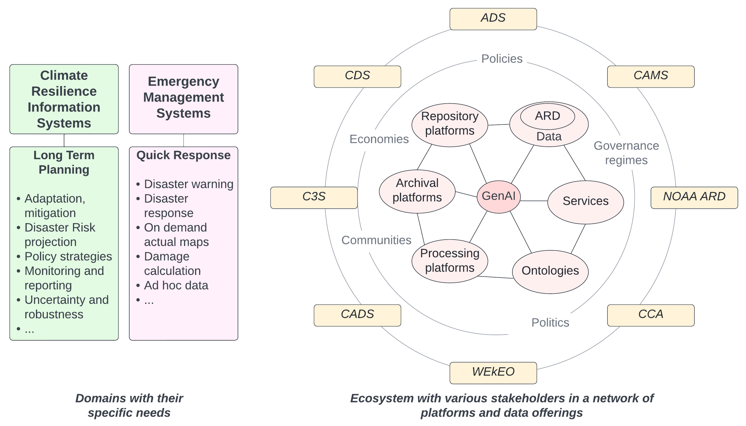
Figure 1. The CDRP24.2 Pilot explores the potential of generative AI in the context of operational platforms and data offerings (right, orange), considering the domain-specific needs of the climate resilience and emergency management communities (left).

Alignment with UN SDGs

The pilot aligns closely with the United Nations Sustainable Development Goals (UN SDGs) and broader climate resilience objectives, reinforcing global efforts to combat the impacts of climate change and promote sustainable development.


SDG 13: Climate Action

Focusing on improving preparedness and response to climate-related disasters. Emphasis on generative AI and geospatial data integration enhances capabilities for monitoring, predicting, and mitigating climate impacts, contributing to informed policy-making and community resilience.

SDG 11: Sustainable Cities and Communities

Fostering solutions that strengthen urban resilience against disasters. AI-driven tools empower local governments and urban planners to identify vulnerabilities, optimize resource allocation, and improve disaster management strategies.p>

SDG 17: Partnerships for the Goals

Reflects the collaborative approach involving governments, private sector entities, academic institutions, and NGOs. This partnership-driven strategy ensures the development of scalable, standards-compliant solutions that address the needs of multiple sectors and regions.

GenAI Challenges

Challenges in Exploiting GenAI within the Climate Resilience Domain

Generative AI holds significant potential for geospatial applications like climate resilience and disaster management but faces critical challenges. GenAI systems often struggle with geospatial complexities, dynamic data, and domain-specific needs.


Geospatial Awareness in Generative AI Systems

GenAI systems lack intuitive spatial reasoning and rely on static data, leading to difficulties in interpreting geographic contexts. This results in fragmented outputs, challenges in resolving ambiguous place names, and an inability to adapt to temporal changes, such as shifting boundaries or urban development.

Hallucinations in the Geospatial Domain

GenAI is prone to hallucinations—generating incorrect or fabricated data—due to ambiguous inputs or incomplete training. These errors can misrepresent spatial relationships or invent non-existent features, such as fictional landmarks.

Understanding the Dynamics of Climate Systems

Climate systems are highly complex, with feedback loops, non-linear changes, and multi-scale variability. GenAI often fails to capture these dynamics without extensive customization. Non-linear changes, where small shifts lead to significant impacts, challenge AI's ability to provide accurate predictions for climate resilience.

Aligning GenAI with Geospatial Standards

Geospatial standards ensure data quality and consistency, which GenAI depends on for reliable outputs. However, the lack of AI-specific standards and the complexity of integrating multi-layered geospatial data pose significant challenges.

Integration with Application Programming Interfaces (APIs)

APIs enable GenAI to access real-time data and perform dynamic analyses but introduce challenges like rate limits, privacy concerns, and dependency management. Frequent API changes or restrictions can disrupt workflows, while latency issues affect time-sensitive tasks.

GenAI Virtual Assistants Responses Validation

Validation Practices Against Hallucinations

GenAI assistants for the geospatial domain can leverage Retrieval-Augmented Generation (RAG) to combine real-time data retrieval with generative capabilities, ensuring that insights are both accurate and contextually relevant. 11 practices can help validate AI outputs and minimize the risk of hallucinations.


1. Cross-Referencing with Authoritative Data
Compare AI-generated outputs with verified datasets or authoritative sources, such as government geospatial databases or satellite imagery.
2. Ground-Truth Datasets
Use curated and validated datasets as training and testing benchmarks to minimize inaccuracies during model development.
3. Spatial Consistency Checks
Verify spatial relationships in AI outputs to ensure they align with known geographic rules and structures.
4. Confidence Scoring
Require AI models to assign confidence scores to their outputs, indicating the certainty of their predictions.
5. Human-in-the-Loop Validation
Incorporate domain experts or users into the validation process to review and correct AI outputs.
6. Feedback Loops
Implement mechanisms for users to provide feedback on errors or inaccuracies in outputs, enabling iterative improvement.
7. Multimodal Validation
Use multiple data types (e.g., textual descriptions, satellite images, GIS layers) to cross-validate AI outputs.
8. Consistency with Domain Knowledge
Ensure that outputs align with known domain-specific principles and constraints.
9. Synthetic Data Testing
Test the model with synthetic or simulated scenarios to assess its performance in edge cases.
10. Regular Model Updates
Periodically retrain models with updated data to account for temporal changes, such as new developments or natural disasters.
11. Chain-of-Thought Reasoning
Guide AI through step-by-step logical reasoning to improve accuracy in geospatial queries.

ARD Maturity Report (D010)

Evaluating ARD Maturity for Climate and Disaster Resilience

The Analysis Ready Data Maturity Report evaluates the maturity of ARD sources for disaster risk response and climate assessments, focusing on NOAA data sources. Read the full report here.

It reviews three major data maturity assessment models—Data Stewardship Maturity Matrix (DSMM), CEOS (Committee on Earth Observation Satellites) Analysis Ready Data (CEOS-ARD), and WGISS (Working Group on Information Systems and Services) Data Management and Stewardship Maturity Matrix (DMSMM)—and develops an updated data maturity matrix combining their strengths.

The report highlights the importance of data quality, accessibility, and interoperability, and evaluates datasets like NOAA’s Climate Data Record of Passive Microwave Sea Ice Concentration and Landsat Collection 2 Surface Reflectance.

It also identifies the need for tools to maximize automation in data maturity evaluation, emphasizing the development of a comprehensive suite for ARD maturity assessment.


Data Maturity

Assess ARD using an updated Data Maturity Matrix integrating CEOS-ARD, DSMM, and DMSMM frameworks.

Evaluation Tools

Leverage compliance test tools and self-service assessment templates for automated data validation.

Future Outlook

Enhance ARD automation, FAIR compliance, and integration into climate and disaster resilience frameworks.


Advancements in ARD maturity ensure:

Structured assessment using standardized maturity frameworks.
Improved data accessibility and integration with AI-driven analytics.
Enhanced disaster response capabilities through reliable and high-quality ARD.

Generative AI for Wildfire Monitoring (D030)

Exploring AI-driven advancements in wildfire detection and response

The Generative AI for Wildfire State-of-the-Art Report Engineering Report (D030) builds upon the findings of Phase 1 (D-123) from the OGC Disaster and Climate Resilience Pilot III. Read the full report here.

This report focuses on advancing Generative AI applications for wildfire risk analysis, social impact assessment, and emergency response, particularly in the Canadian wildland fire insurance sector. Wildfire management depends on robust data insights and advanced tools that enhance, rather than replace, expert decision-making. The goal is to enhance preparedness, operational efficiency, and risk management through AI-powered insights.


Use Cases and Functionalities

The report outlines key GenAI-driven use cases for wildfire resilience, response, and risk assessment, with a primary focus on the Canadian wildfire insurance sector.

Data Sources and FAIR Evaluation

The report includes an inventory of over 200 Canadian wildfire-related data sources.

OGC Compliance and Interoperability

The report aligns with OGC best practices, ensuring cross-agency data integration and AI model transparency.


Generative AI enhances wildfire resilience by:

Automating real-time wildfire monitoring from satellite and aerial data.
Improving predictive analytics for fire behavior and containment strategies.
Enabling seamless data integration for early warnings and rapid response.

Information Interoperability Report (D040)

Integrating Environmental Data with Semantic Ontologies

The Information Interoperability Engineering Report (D040) presents methodologies for information modeling and interoperability assessment. It identifies existing gaps, key lessons learned, and provides recommendations to improve interoperability between Department of Defense/Intelligence Community (DoD/IC) ontologies and Open Geospatial Consortium (OGC) APIs. Read the full report here.


Ontology Alignment

Develops a shared ontology framework that integrates OGC Environmental Data Retrieval (EDR) with the Common Core Ontology (CCO), ensuring consistency and accuracy.

Concept Mapping

Establishes structured mappings between key environmental data concepts and ontology terms, facilitating seamless information exchange.

Semantic Queries

Enables AI-driven retrieval and integration of geospatial data through standardized, ontology-based search mechanisms.


Recommendations:

Enhance ontology-driven metadata structures to improve cross-domain interoperability.
Develop scalable RDF/OWL models for harmonizing environmental and geospatial data.

Foster collaboration between geospatial standards organizations and AI-driven analytics platforms.


GenAI Case Studies

Case Studies and Prototypes

Real-world applications showcasing the power of Generative AI in climate resilience and disaster management.


Demonstrators for Virtual AI Assistants

GeoLabs (D100)
AI Assistant to search, retrieve, and analyze climate-related datasets.
CCMEO (D110)
Generative AI chatbot on GEO.ca.
Danti (D110)
AI-powered geospatial intelligence for government agencies.
CRIM (D120)
Demonstrator for flood risk analysis using GenAI.
GIS.FCU (D120)
AI-virtual assistant for data-driven decision-making.
TerraFrame (D120)
AI Assistant for Disaster Impact Analysis using SKGs.

Demonstrators for Sectoral Applications

Hartis (D101)
AI-Assisted Coastal Vulnerability Analysis.
Pyxalitics (D101)
Health Impact AI Demonstrator.

>

GeoLabs (D100)

AI Assistant to search, retrieve, and analyze climate-related datasets.

Demonstrator | Presentation Portal


Use Cases

The virtual assistant enhances geospatial data discovery and usability through conversational AI. It allows users to efficiently search, retrieve, and analyze climate-related datasets via natural language queries. The assistant integrates Retrieval-Augmented Generation (RAG), web-based search, and multiple LLM models, ensuring accurate and relevant responses.

Findings

  • RAG-based search significantly improves AI response accuracy.
  • Markdown indexing enhances LLM processing efficiency.
  • High-quality data cleaning optimizes search accuracy.
  • GPU-powered inferencing reduces response generation time.
  • Effective prompt engineering enhances AI query relevance.


CCMEO (D110)

Generative AI chatbot on GEO.ca


Use Case

The demonstrator explores embedding a Generative AI chatbot on GEO.ca to enhance search and discovery of FAIR and Open geospatial data through a conversational interface. The chatbot aims to support researchers, policymakers, educators, and citizens by enabling natural language queries, contextual search, and data visualization capabilities.

Findings

Experimentation with a generative AI chatbot currently under development revealed several key challenges.

  • Hallucinations in AI-generated responses remain a challenge when data isn't sourced from authoritative APIs.
  • Low confidence in results occurs when datasets lack clear metadata or structured retrieval mechanisms.
  • Infrastructure costs for training, fine-tuning, and scaling pose barriers to full implementation.


Danti (D110)

AI-powered geospatial intelligence for government agencies

https://gov.danti.ai/log-in

Please send an email to [email protected] to approve the account.


Use Case

The demonstrator showcases how Danti.ai enhances government agencies’ ability to search, analyze, and interpret multimodal geospatial data. The system enables contextual search, knowledge graph-based insights, by integrating Generative AI with government and commercial data sources, and interactive mapping to support decision-making in national security, disaster response, and infrastructure planning.

Findings

Initial deployment of Danti.ai for government applications revealed several challenges:

  • Ensuring data reliability by integrating authoritative sources to mitigate AI-generated hallucinations.
  • Enhancing metadata completeness to improve AI confidence in geospatial search results.
  • Optimizing computational resources to scale AI capabilities while managing infrastructure costs.


CRIM (D120)

Demonstrator for flood risk analysis using GenAI.

https://ogc-demo.crim.ca


Use Case

The demonstrator leverages Generative AI to create a virtual assistant that interacts with geospatial data, using maps as a conversational interface. Instead of relying on structured APIs, the system allows users to query flood risk maps and other overlays using natural language, making geospatial analysis more intuitive and accessible. A prototype was developed to test this concept, focusing on flood risk assessments, enabling AI-assisted visual interpretation of geospatial data to support decision-making in disaster management.

Findings

  • Generative AI effectively interprets flood risk maps, providing location-specific risk assessments.
  • Structured AI prompting (JSON, Chain-of-Thought) improves response reliability.
  • AI-generated insights are enhanced by integrating geospatial APIs (e.g., geocoding services).
  • AI models struggle with ambiguous or imprecise geographic references, requiring validation mechanisms.
  • Hallucinations occur, such as misidentifying flood zones or generating non-existent locations.


GIS.FCU (D120)

AI-virtual assistant for data-driven decision-making.

https://ryan19981229.github.io/ogc-demo-web/


Use Case

The demonstrator is capable of answering users’ queries in plain text about the risks, hazards, and impacts of coastal flooding in Canada.
"I can help you prepare for floods by providing information on staying updated with local weather, protecting your home, dealing with mold, and cleaning flood-damaged areas. I can also assist in understanding natural hazards and preparing an emergency kit. Additionally, I can guide you on disposing of contaminated household items and protecting against foodborne illnesses."

Findings

  • Integrating Retrieval-Augmented Generation (RAG) significantly enhanced the accuracy and contextual relevance of the virtual assistant’s responses.
  • The pilot highlighted the importance of comprehensive metadata and standardized formats to facilitate interoperability across datasets.
  • Scaling the system to accommodate larger datasets and more complex scenarios will require optimized computational resources and more sophisticated indexing strategies.
  • Future development, by including the incorporation of real-time data streams, support for multilingual queries, and advanced visualization tools to complement textual outputs.

By Exile on Ontario St from Montreal, Canada - 2017 Quebec Floods - Montreal, CC BY-SA 2.0, Link

TerraFrame (D120)

AI Assistant for Disaster Impact Analysis using SKGs.

https://genai.usace.geoprism.net

Please contact [email protected] for credentials.


Use Case

The demonstrator integrates GenAI and spatial knowledge graphs (SKGs) to address complex challenges in climate disaster impact analysis. The pilot employed a geo-ontology to explore methods of enhancing geospatial awareness in LLMs and demonstrated how flooding events (e.g., levee breaches) impact school zones.

Findings

The pilot explored various approaches for integrating geospatial awareness into LLMs:

  • Using LLMs to generate Cypher queries, proved most reliable for identifying cascading disaster effects with multiple degrees of separation in an SKG.
  • Tested vector-embedded RAG models using RDF triples but found structured Cypher queries via ReAct agent more effective.
  • Ensuring traceability in AI-generated outputs, provides transparent justifications for disaster impact assessments, improving trust and decision confidence.


Hartis (D101)

AI-Assisted Coastal Vulnerability Analysis.

https://cdrp.hartis.org


Focus

The Demonstrator integrates Generative AI to enhance the analysis and visualization of coastal resilience metrics. The tool utilizes the LLaMA 3 model to interpret user queries, retrieve relevant geospatial data from Copernicus services, and compute the Coastal Vulnerability Index (CVI).

Highlights

Combining AI-driven workflows, dynamic mapping, and plain-language explanations, the demonstrator makes complex environmental data more accessible and actionable for a diverse range of users, including policymakers, researchers, and the public.

Lessons

Its ability to process and visualize geospatial data dynamically makes it a valuable tool for coastal risk assessment, disaster preparedness, and climate adaptation planning. Further refinements and stakeholder engagement will enhance its effectiveness in supporting real-world decision-making.


Pyxalitics (D101)

Health Impact AI Demonstrator.

https://github.com/pixalytics-ltd/Climate-drought


Focus

The Demonstrator leverages data-driven workflows to analyze the health impacts of heatwaves and droughts. The pilot integrates advanced climate data processing with analytical tools to support informed decision-making in the health sector.

Highlights

Utilizing Python-based libraries and ERA5 datasets, the workflow processes precipitation and temperature-related indices, including the Standardized Precipitation Index (SPI) and the Universal Thermal Climate Index (UTCI). These indices enable the development of analysis-ready data, which can be queried, visualized, and combined to derive actionable insights.

Lessons

The developed code has been deployed and tested on the WEkEO platform, enabling cloud-based execution within a harmonized data infrastructure. Future efforts will enhance computational performance, explore automated anomaly detection, and further refine the Health Index calculations to better inform climate adaptation strategies.


Findings

During the pilot, several challenges in integrating AI with geospatial data were identified:

Geospatial Awareness & Reasoning

AI struggles with ambiguous geographic references, requiring ontology mapping and structured tagging to improve spatial reasoning and contextual understanding.

AI Hallucinations & Validation

AI models can generate misleading or incorrect geospatial insights due to gaps in structured data retrieval. Implementing validation mechanisms such as authoritative datasets, metadata tagging, and automated geospatial checks reduces errors.

Data Interoperability & Standards Compliance

Inconsistent metadata standards and a lack of cross-platform compatibility create challenges in integrating geospatial data from multiple sources. Harmonization through standardized metadata and compliance with geospatial standards is needed.


Key findings from these challenges include:

Geographic Ambiguity

AI struggles with places that have similar names, undefined boundaries, or vague geographic references. Validation mechanisms, including authoritative datasets and structured tagging, are critical for accuracy.

Structured AI Prompting

Using structured AI prompting methods such as JSON formatting and Chain-of-Thought reasoning significantly improves response accuracy. Guiding AI step-by-step through complex queries reduces errors.

Geospatial APIs

Integrating geospatial APIs, such as geocoding services, enhances AI-generated insights by enabling cross-referencing with verified geographic data, improving spatial awareness and reducing hallucinations.

Recommendations

To enhance AI applications in climate resilience and disaster management, the following actions are recommended:

AI Validation & RAG Implementation

Combining retrieval-augmented generation (RAG) models with automated geographic validation mechanisms ensures AI-generated outputs are accurate and aligned with authoritative geospatial sources.

Geospatial Knowledge Graphs & Structured Learning

Graph-based reasoning models, such as Spatial Knowledge Graphs, improve AI’s ability to process geospatial relationships and enhance contextual awareness.

Data Interoperability & FAIR Compliance

Enhancing metadata models (ISO 19115), establishing ontology crosswalks, and conducting FAIR compliance assessments improve geospatial data discoverability and usability.


AI-Driven Disaster & Emergency Modeling

AI-powered risk assessments should integrate real-time geospatial data to support disaster monitoring, resource allocation, and emergency response strategies.

AI for Climate Resilience Planning

Leveraging AI-driven climate risk assessments supports urban planning, policy-making, and disaster mitigation strategies, ensuring proactive resilience measures.

Cross-Sector AI-Geospatial Partnerships

Fostering collaboration between AI researchers, geospatial scientists, emergency responders, and policymakers ensures the development of AI-powered geospatial solutions tailored for climate resilience.

Climate-GenAI Future

Future Outlook

GenAI has the potential to revolutionize climate and disaster resilience efforts by enabling predictive analysis, early warning systems, and adaptive planning. The integration of GenAI with geospatial data can support decision-making for disaster response, climate adaptation, and risk mitigation. GenAI offers transformative potential in geospatial applications, but its effective integration depends on strategic actions, such as the prioritization of data quality, availability, and interoperability.


Strategic Directions

Enhance Data Interoperability

Refine standards, ontologies, and metadata frameworks to ensure seamless data integration and sharing across platforms.

Develop Scalable AI Prototypes

Design and implement scalable AI-driven solutions to expand their applicability across various climate resilience and disaster management domains.

Strengthen Cross-Sector Collaboration

Foster partnerships between governments, academia, and the private sector to drive innovation and collaborative AI research.


Key Areas for Further Research

Develop Large Spatial Models (LSMs) to enhance geospatial reasoning and predict cascading climate impacts with greater accuracy.
Improve AI explainability and uncertainty quantification to ensure responsible and reliable applications in life-critical geospatial scenarios.
Advance multimodal AI by integrating Earth Observation (EO), LiDAR, sensor networks, and crowd-sourced disaster data for comprehensive situational awareness.